Mountain Lion Habitat
Understanding the complex ecological requirements that support potential mountain lion populations in Wisconsin's evolving landscape. This page documents habitat characteristics, territory requirements, and environmental factors influencing panther presence in Manitowoc County.
Essential Habitat Characteristics
Mountain lions (Puma concolor) require specific habitat elements to establish sustainable territories. These elusive predators historically roamed throughout Wisconsin but were extirpated by the early 1900s due to hunting and habitat loss. Recent verified sightings in neighboring states suggest a gradual recolonization of their former range.
Key habitat requirements include:
- Cover & Concealment: Dense forest patches with understory vegetation providing daytime resting spots and ambush opportunities
- Prey Availability: Abundant white-tailed deer populations serving as primary food source, supplemented by smaller mammals
- Denning Sites: Protected locations such as rock outcroppings, hollow logs, or dense thickets for raising young
- Travel Corridors: Linear landscape features like river systems, ridgelines, and forested strips connecting habitat patches
- Limited Human Disturbance: Areas with minimal human development and activity, particularly during crepuscular hunting periods
A single male mountain lion may require 50-150 square miles of suitable habitat, while females typically maintain smaller territories of 25-60 square miles. This extensive spatial requirement presents challenges in Wisconsin's fragmented landscape.
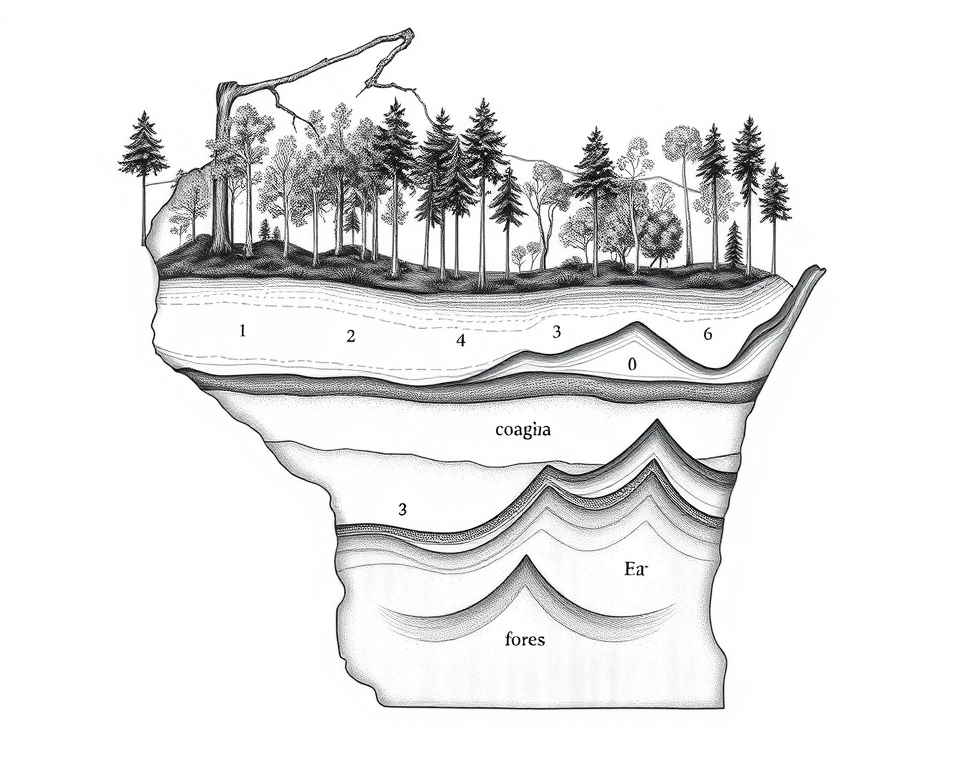
Margin Notes — Habitat Elements
The cross-section diagram illustrates ideal habitat structure showing: (1) Mature canopy providing protective cover; (2) Mid-story vegetation supporting prey species; (3) Rocky outcroppings offering denning sites; (4) Understory cover for stalking; (5) Riparian zones serving as travel corridors; (6) Edge habitat increasing deer abundance. Note how these elements combine to provide both hunting opportunities and security.
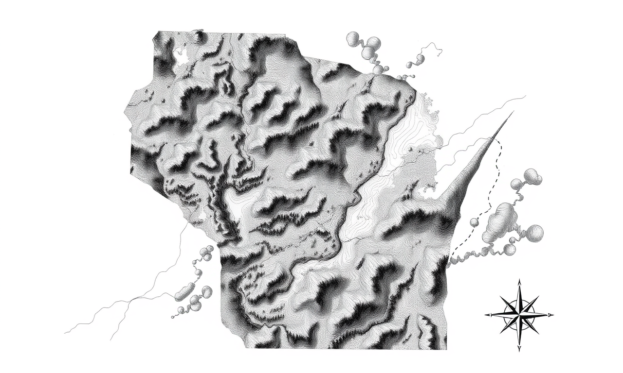
Margin Notes — Territory Mapping
The topographical map highlights: (A) Core forest blocks exceeding 1,000 acres; (B) Riparian corridors providing movement pathways; (C) Potential road crossing hotspots requiring monitoring; (D) Areas with documented ungulate concentrations; (E) Habitat fragments requiring conservation attention to maintain connectivity. Dotted lines indicate hypothetical movement corridors based on landscape permeability analysis.
Wisconsin Habitat Distribution
Wisconsin's landscape presents a complex mosaic of potential mountain lion habitat. The state's northern forests provide the most extensive suitable area, while central and southern regions offer fragmented but potentially viable patches connected by riparian corridors.
Manitowoc County habitat features:
- Forest Fragmentation: The county contains approximately 43,000 acres of forested land, primarily in scattered woodlots and riparian zones, presenting challenges for large carnivore movement
- Point Beach State Forest: The 3,000-acre coastal forest provides the largest contiguous habitat block in the county, offering potential core territory
- River Corridors: The Manitowoc, Branch, and Twin Rivers create natural movement pathways connecting forest fragments
- Agricultural Matrix: Farmland comprising 65% of county land creates open areas that cougars typically avoid during daylight but may traverse at night
- Human Development: Rural population density averages 85 people per square mile, with extensive road networks creating potential barriers and mortality risks
Our habitat suitability analysis identifies several potentially viable zones in the county's northern and eastern sections where forest patches, prey density, and limited human disturbance combine to create conditions that could support transient or resident mountain lions.
Habitat Challenges & Conservation
Fragmentation Effects
Wisconsin's landscape has undergone significant transformation since mountain lions historically roamed the region. Forest fragmentation has reduced habitat blocks to sizes often insufficient for establishing permanent territories.
Male dispersers seeking new territory typically follow riparian corridors and forested connections, but gaps exceeding 3-5 miles of open terrain may inhibit movement, particularly in daylight hours when human detection risk increases.
Conservation Focus
Maintaining and enhancing forest corridor connections between habitat blocks is essential for enabling population establishment and genetic exchange.
Human-Wildlife Interface
While mountain lions typically avoid human encounter, Wisconsin's rural landscape creates inevitable interface zones where human activity and potential lion habitat overlap.
Research from states with established populations indicates cougars adapt behaviorally to human presence by becoming increasingly nocturnal and avoiding areas of concentrated human activity while still utilizing peripheral zones.
Conservation Focus
Public education about cougar behavior and simple precautionary measures can minimize negative interactions in shared landscapes.
Prey Availability
Wisconsin's robust white-tailed deer population provides adequate prey base for potential mountain lion establishment. The state's estimated 1.8 million deer exceed density thresholds observed in established cougar territories elsewhere.
Manitowoc County's deer density averages 25-30 deer per square mile, sufficient to support predator presence. Studies indicate a single mountain lion typically harvests 50-60 deer annually.
Conservation Focus
Maintaining ecological balance between predators and prey requires science-based management of both deer populations and potential predators.
Current Research & Monitoring
The Manitowoc County Panther Watch maintains several research initiatives focused specifically on habitat analysis and monitoring:
- Remote Camera Network: 32 trail cameras strategically placed in potential habitat corridors and crossing points, checked monthly for evidence
- GIS Habitat Connectivity Analysis: Ongoing mapping project identifying critical linkages between habitat patches requiring conservation attention
- Track Surveys: Seasonal systematic surveys of sandy terrain and mud areas near water sources where tracks may be preserved
- Landowner Habitat Assessment: Free evaluations for property owners interested in managing land to improve wildlife corridors
Habitat Improvement Guidelines
Landowners interested in supporting wildlife corridors and habitat connectivity can implement these conservation practices:
- Maintain and expand forested patches, especially those connecting to larger habitat blocks
- Preserve riparian vegetation along streams and rivers to at least 100 feet width
- Implement wildlife-friendly fencing designs with 16" minimum ground clearance
- Create wildlife underpasses where property roads cross potential movement corridors
- Maintain brush piles and edge habitat that support small mammal populations
- Minimize outdoor lighting that may disrupt nocturnal movement patterns
- Consider conservation easements for critical habitat zones
"Conservation of apex predators requires landscape-scale thinking. Each preserved corridor and habitat patch contributes to the ecological network necessary for sustainable wildlife populations."
— Dr. Johnny Bananas
Join Our Habitat Monitoring Network
Help us document and protect potential mountain lion habitat in Manitowoc County. Whether you own land, have technical skills, or simply time to volunteer, your contribution matters.